RSS

Welcome to Theo Appartments


 Services


 Rooms

Click over the picture


ΟΛΥΜΠΙΑΚΗ ΑΚΤΗ

Αμμώδης ακτή, εκτείνεται σε μήκος αρκετών χιλιομέτρων με λεπτή, καθαρή άμμο και ρηχή θάλασσα. Βραβεύεται κάθε χρόνο με την γαλάζια σημαία της Ευρώπης και κατακλύζεται κάθε καλοκαίρι από πολύ μεγάλο αριθμό τουριστών.

Προσφέρεται σημαντική δυνατότητα για διαμονή σε ένα πλήθος από ξενοδοχεία και ενοικιαζόμενα δωμάτια, καθώς και σε μπανγκαλόου και κάμπινγκ. Πολυάριθμα εστιατόρια, ταβέρνες και κάθε είδους μέσα εστίασης σας περιμένουν να γευτείτε τόσο την τοπική όσο και τη διεθνή κουζίνα. Πολλά και ποικίλα κέντρα διασκέδασης φροντίζουν για την ψυχαγωγία και τη νυχτερινή σας διασκέδαση.

Η Ολυμπιακή Ακτή βρίσκεται στο κέντρο του Νομού Πιερίας και ανήκει διοικητικά στο Δήμο Κατερίνης. Συνδέεται με την ακτή της Παραλίας με φωταγωγημένη παραλιακή λεωφόρο, με παράλληλο ποδηλατόδρομο και πεζόδρομο για νυχτερινούς περιπάτους και αξέχαστα πρωινά.

Απέχει μόλις 8 χιλιόμετρα από την Κατερίνη και η πρόσβαση είναι πολύ εύκολη από τον Εθνικό Αυτοκινητόδρομο Ε75 (κόμβος Κατερίνης), την παραλιακή επαρχιακή οδό Νέας Αγαθούπολης - Ολυμπιακής Ακτής και το Σιδηρόδρομο (Σταθμός Κατερίνης).


OLYMPIC BEACH

A sandy beach stretching for several kilometres, clean sand and shallow sea, Olympic Beach has been regularly awarded the European Blue Flag for many years, and attracts a large number of tourists every summer.

There is a wide range of accommodation for you to choose for your stay, including Hotels, rooms to rent and bungalows and a campsite. A great array of restaurants and taverns of every type are waiting to cater for your tastes with both local and international cuisine.

Olympic Beach marks the central point of the County of Pieria and belongs to the Municipality of Katerini.

The beaches of Paralia and Olympic Beach are one continuous stretch of golden sand, the two communities being linked by a well lit avenue with a bicycle track running alongside and a path for pedestrians wishing to take either a morning or evening stroll.

Situated just 8 kms from Katerini, it is easily reached from The National Motorway E75 (Junctions: Katerini or Korinos) and from the recently completed coastal road from Nea Agathoupoli to Olympic Beach (Katerinoskala). It is also served by the railway from Salonika to Athens (Station: Katerini).


OLYMPIAKI AKTI

Wundervoller Sandstrand mit feinem sauberem Sand und blaues Meer mit seichtem, kristallklarem Wasser. Der Strand von Olympiaki Akti wird schon seit Jahren mit der europaischen Blauen Flagge ausgezeichnet und ist in den Sommermonaten ein Anziehungspunkt fur zahlreiche Touristen.

In den zahlreichen Hotels, Privatzimmern, in den Bungalows und auf dem Campingplatz finden Sie ausgezeichnete Unterbringungsmoglichkeiten, die jedem Anspruch gerecht werden. Unzahlige Restaurants, Tavernen und andere Gaststatten bewirten Sie gern mit vorzuglichen griechischen aber auch internationalen Kostlichkeiten. Die zahlreichen Nachtlokale und Vergnugungsstatten sorgen bis in die Morgenstunden fur Ihre Unterhaltung.

Olympiaki Akti liegt genau in der Mitte der kilometerlangen Kuste von Pieria und gehort verwaltungsma?ig zur Stadt Katerini. Die Uferstra?e mit der schonen beleuchteten Strandpromenade und ein Radweg verbinden Olympiaki Akti mit dem Nachbarort Paralia. Die Uferpromenade ladt in den Abendstunden, in den klaren Nachten oder im Morgengrauen zu unvergesslichen Spaziergangen ein.

Olympiaki Akti liegt nur 8 km von Katerini, der Hauptstadt der Prafektur Pieria, entfernt und ist leicht uber die Autobahn E 75 (Abfahrt Katerini), die Uferstra?e Nea Agathoupoli - Olympiaki Akti, aber auch mit der Eisenbahn (Bahnhof Katerini) zu erreichen.


See more pictures

  • Digg
  • Del.icio.us
  • StumbleUpon
  • Reddit
  • RSS

STREAM OF ORLIA (Directions & Video)

Stream of orlia we reach it from village Dion.

At the point (n 40 10.396 e 022 29.213) we turn for mountain olympus following the signs for olympus and stream orlia. As soon as we reach in the little church of saint konstantinos and helen the road immediately afterwards it makes a big left turn and continues dirt road. Above this turn it begins the path in very dense forest. At the point (n 40 08.451 e 022 25.858) we follow the path that leads right to the stream and no straight line above for koromilia.

After we reach in the stream we continue up to the stream following the white marks and being careful the slick rocks. You will need aboyt one hour of hike to get there. The cache is a film canister hidden in a horizontal slot in the eyes – high , that is created by two big rocks the one above on the other. Either you find it or not , your reward will be the fabulous waterfall a few meters above.

  • Digg
  • Del.icio.us
  • StumbleUpon
  • Reddit
  • RSS

Cultures mussels (Chalastra)

  • Digg
  • Del.icio.us
  • StumbleUpon
  • Reddit
  • RSS

Βυζαντινός Ναός - Byzantine Church

  • Digg
  • Del.icio.us
  • StumbleUpon
  • Reddit
  • RSS

Ρέμα Ορλιά - Waterfalls of Orlia (Olympus)

  • Digg
  • Del.icio.us
  • StumbleUpon
  • Reddit
  • RSS

ΕΘΝΙΚΟΣ ΔΡΥΜΟΣ ΟΛΥΜΠΟΥ - Olympus


ΕΘΝΙΚΟΣ ΔΡΥΜΟΣ ΟΛΥΜΠΟΥ
Ο Όλυμπος είναι το πρώτο βουνό στην Ελλάδα για το οποίο εφαρμόστηκε το 1938 ειδικό καθεστώς προστασίας με τη ανακήρυξή του σε ΕΘΝΙΚΟ ΔΡΥΜΟ (Β.Δ. 9-6-1938 ΦΕΚ 248Α/1938), ενώ το 1985 εγκρίθηκε ο Κανονισμός Λειτουργίας του Εθνικού Δρυμού (ΦΕΚ 467/25-7-1985 τ. Β'). Το 1981, με απόφαση του Διεθνούς Συμβουλίου του Προγράμματος για τον ’νθρωπο και την Βιόσφαιρα, ο Ο.Η.Ε. αναγνωρίζει τον Εθνικό Δρυμό ως «Τμήμα του Διεθνούς δικτύου των αποθεμάτων της Βιόσφαιρας». Το δίκτυο αυτό των προστατευομένων δειγμάτων του Παγκόσμιου Οικοσυστήματος είναι αφιερωμένο στη διατήρηση της Φύσης και την Επιστημονική έρευνα στην υπηρεσία του Ανθρώπου.

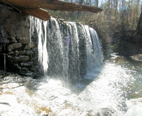
Ιδιαίτερο ενδιαφέρον παρουσιάζει ο Εθνικός Δρυμός ως προς τη Γεωμορφολογία του. Έχει πολλές κορυφές, μεγάλες ρεματιές και βαθιές χαράδρες, αμφιθεατρικές κοιλότητες, σπήλαια και βάραθρα, καθώς και πολλές πηγές, μικρές εποχικές λίμνες και χείμαρρους. Το κλίμα επηρεάζεται από τη γεωγραφική θέση, τον όγκο του βουνού, τα πετρώματα και τις πλαγιές του. Συχνό φαινόμενο είναι η αναστροφή των θερμοκρασιών και της υγρασίας, καθώς και η εμφάνιση πολλών μικροκλιμάτων.

Στον Εθνικό Δρυμό υπάρχουν συνολικά τέσσερις διαδοχικές ζώνες βλάστησης (Μακεία, Δάσος κωνοφόρων - φυλλοβόλων, Ορεινό δάσος κωνοφόρων, Αλπική βλάστηση). Η χλωρίδα του είναι μοναδική, με μεγάλη ποικιλία φυτών, από τα οποία τα 23 είναι ενδημικά. Στην πανίδα του έχουν παρατηρηθεί 32 είδη θηλαστικών, 108 είδη πουλιών, καθώς και μια μεγάλη ποικιλία εντόμων, κυρίως πεταλούδες.

ΧΛΩΡΙΔΑ
Οι μεταβολές των κλιματολογικών συνθηκών, η υψομετρική διαφορά, η ποικιλία του ανάγλυφου και η μικρή απόσταση από τη θάλασσα επηρεάζουν την κατανομή των διαφόρων φυτικών συστημάτων. Υπάρχουν συνολικά πέντε διαδοχικές υψομετρικές ζώνες βλάστησης χωρίς σαφή όρια μεταξύ τους: Από 0 - 300 μ. είναι η ζώνη όπου καλλιεργούνται κυρίως αμπέλια και ελιές, ευδοκιμούν πολλά οπωροφόρα δέντρα και φύονται τα φρύγανα.Από 300 - 700 μ., στη ζώνη των αείφυλλων σκληρόφυλλων (μακκία), υπάρχουν τα πλατύφυλλα αειθαλή με συνηθέστερα είδη καστανιές, δρυς, κουμαριές κ.α.Από τα 700 - 1600μ εκτείνεται η ζώνη με μικτό δάσος κωνοφόρων και φυλλοβόλων. Κυρίαρχο είδος βλάστησης είναι η μαύρη πεύκη. Εμφανίζονται ακόμη η οξιά, σε μικρές ομάδες η ελάτη, σποραδικά η φτελιά, η αγριοκερασιά, ο ίταμος, η κρανιά και μια σημαντική ποικιλία από ποώδη φυτά.

Από τα 1600 - 2100μ. εκτείνεται η ζώνη του ορεινού δάσους κωνοφόρων, με το χαρακτηριστικό και σπάνιο είδος πεύκου το ρόμπολο καθώς και την ορεινή πεύκη. Η ζώνη αυτή αντιπροσωπεύεται από ασθενή ποώδη βλάστηση που περιλαμβάνει σπάνια είδη φυτών, ενδημικά των Βαλκανίων.

Πάνω από το όριο των 2100μ. εκτείνεται η αλπική ζώνη, όπου στα λιβάδια, στους βράχους και στις απότομες πλαγιές ζουν μερικά από τα ωραιότερα ελληνικά αγριολούλουδα και τα περισσότερα ενδημικά φυτά του Ολύμπου.Στη χλωρίδα του Ολύμπου έχουν καταγραφεί μέχρι σήμερα πάνω από χίλια επτακόσια (1700) είδη φυτών, περίπου το 25% της ελληνικής χλωρίδας.Στην γυμνή από δέντρα αλπική ζώνη υπάρχουν πάνω από 150 είδη φυτών. Από αυτά, τα μισά βρίσκονται μόνο στη Βαλκανική χερσόνησο και τα είκοσι τρία (23) είναι ενδημικά του Ολύμπου, μοναδικά στον κόσμο.

ΠΑΝΙΔΑ
Στην πανίδα του Ολύμπου, η οποία περιλαμβάνει σημαντική ποικιλία ειδών, έχουν καταγραφεί τριάντα δύο (32) είδη θηλαστικών, όπως το αγριοκάτσικο (fupicapra rupicapra), το ζαρκάδι (capreolus capreolus), το αγριογούρουνο (sus scrofa), η αγριόγατα (felis sulvestris), το κουνάβι (martes foina), η αλεπού (vulpes vulpes), ο σκίουρος (sciurus vulgaris) κ.α.. Στα οκτώ διαφορετικά οικοσυστήματα του δρυμού, από τα 300μ. μέχρι τα 2918μ., έχουν παρατηρηθεί εκατόν τέσσερα (104) είδη πουλιών ορισμένα από τα οποία είναι σπάνια. Από τα απειλούμενα με εξαφάνιση είδη φωλιάζουν ή τρέφονται στην περιοχή του δρυμού 11 είδη αρπακτικών (το 41% του πληθυσμού της Ευρώπης), όπως ο Γυπαετός (Gypaetus Barbatus), ο Μαυρόγυπας (Aegypius monachus), ο Φιδαετός (Circaeyous gallicus), το Σαΐνι (Accipiter brevipes), ο Χρυσαετός (Aquila chrisaetos), το Χρυσογέρακο (Falco biarmicus) και ο Πετρίτης (Falco peregrinus) και 7 είδη δρυοκολαπτών (το 70% του πληθυσμού της Ευρώπης). Έχει ακόμη μία σπάνια ερπετοπανίδα (φίδια, χελώνες, σαύρες, κ.λ.π.), ορισμένα αμφίβια στα ρέματα και τις εποχικές λίμνες και μια μεγάλη ποικιλία εντόμων, κυρίως πεταλούδες για τις οποίες ο Όλυμπος φημίζεται.

ΜΙΚΡΟΚΛΙΜΑ
Το κλίμα του Ολύμπου στις χαμηλότερες περιοχές είναι τυπικά μεσογειακό, δηλαδή θερμό και ξηρό το καλοκαίρι, ενώ υγρό το χειμώνα.Στις ψηλότερες περιοχές είναι πιο υγρό και πέφτει συχνά χιόνι όλο το χειμώνα, ενώ η βροχή είναι συνηθισμένο φαινόμενο και το καλοκαίρι.Η θερμοκρασία κυμαίνεται τον χειμώνα από -20 μέχρι -10 βαθμούς Κελσίου και το καλοκαίρι γενικά από 0 μέχρι 20 βαθμούς Κελσίου, ενώ οι άνεμοι είναι σχεδόν καθημερινό φαινόμενο. Η έντονη ποικιλομορφία του ανάγλυφου, ο διαφορετικός προσανατολισμός των δασωμένων πλαγιών και η θέση τους σε σχέση με την θάλασσα επηρεάζουν κατά τόπους το κλίμα του. Έτσι παρατηρείται το συχνό φαινόμενο της αναστροφής θερμοκρασιών και υγρασίας και η εμφάνιση πολλών μικροκλιμάτων. Όλα αυτά, σε συνδυασμό με το γεωλογικό υπόβαθρο και το έδαφος, ευνοούν την ανάπτυξη ιδιαίτερων τύπων βλάστησης και χαρακτηριστικών βιοτόπων.


MOUNT OLYMPUS

Mount Olympus is famous throughout the world for its history, its cultural significance and its ecological treasures as well as its place in mythology. An entire Greek ecosystem is contained within its graded heights. It is the highest mountain in Greece, rising to 2,918 metres, with a lengthy Alpine belt above 2,500 m. and more than 10 peaks exceeding 2650 m. The highest peaks are Mytikas (2,918 m.) followed by Skolio (2911 m.) and Stephani (2909 m.), together forming a central group.Lying to the North West of Olympus, and just as vast, is the mountain range of Titaros Over 1700 varieties of plants have been identified on Olympus, 23 of which are unique to the region, to be found nowhere else on this earth.

These are complemented by a wealth of animal and bird life, including 32 species of mammal, 108 types of bird, numerous reptiles and snakes and a great variety of insects, principally butterflies. In 1938 Olympus was declared a "National Forest" and in 1981 its worldwide importance was declared an "International Area of outstanding environmental significance to the biosphere". Each year the mountain attracts thousands of visitors from all over the world.

Olympus was the first mountain in Greece to be afforded protection under legislation, which awarded it the status of a "National Park", this being ratified in 1985 under new regulations concerning places of outstanding natural beauty. In 1981, under the auspices of The International Committee for Mankind and the Biosphere, the National park was recognised as an "area of international importance for the environment of mankind". Olympus is held up worldwide as an example of a protected ecosystem. It is dedicated to the protection of the natural habitat of this vast resource of plant and animal wildlife, and is available for scientific research in the worldwide service of mankind.

Of particular interest is the land formation of the area. With its countless peaks, deep gorges, magnificent ravines, hollow amphitheatres, caves and chasms, as well as a multitude of springs, lakes and ponds and fast flowing torrents of water it offers a terrain of infinite variety.

The climate is influenced by its geographical situation, the massive bulk of the mountain, its rocky nature and its slopes. This frequently causes what is known as "heat inversion" and the existence of many "micro climates" due to these factors and the moisture content of the air.
Generally speaking, there are four identifiable levels of vegetation within the National Park. At the lowest level there are the usual trees, bushes, shrubs and vegetation common to this altitude. The next level has mainly mixed deciduous and coniferous trees, the third level consists of mountainous forests of coniferous pine trees and, at the highest level, Alpine vegetation. The plant life of the region is unique with a wide variety of indigenous species, 23 of which are only to be found here. Fauna recorded includes 32 species of mammal, 108 varieties of birds as well as a wealth of insects, notably butterflies.

FLORA
The changes in the climatic conditions, the varying heights, the variety of relief and the proximity of the sea have influenced the distribution of the different plant systems.
There are five successive belts of vegetation identifiable at the different levels, in addition to the distinct mountain ranges between them:
From 0 - 300 m.: suitable principally for the cultivation of grapes and olives, fruit trees flourish and bushes spring up.
From 300 - 700 m.: hardy and flat leaved evergreens are to be found here as well as varieties of Oak, Chestnut and Arbutus.
From 700 - 1600 m.: an extensive forest of pine and fir, principal among which is the Black Pine. Beech trees also appear and occasional elm Wild Cherry trees are to be found.
From 1600 - 2100 m.: mostly mountain pine including a rare variety, the Rompolo.
Above 2100 m. is the Alpine Zone, with rocky plains and steep gorges where some of the scarcest and most beautiful of the wild flowers of Olympus live.
More than 1700 different types of plant life have been recorded on Olympus to date, which is approximately one quarter of the known plant population of Greece.
There are over 150 different varieties of plant above the tree line on the bare rock faces of the mountain. Of these, half are to be found only in the Balkans and 23 are indigenous to Olympus, unique worldwide.

FAUNA
The Fauna of Olympus includes a variety of important species, notable among which are the wild goat (fupicapra rupicapra), the roedeer (capreolus capreolus), the wild boar (sus scrofa), the wildcat (felis sulvestris), the Pine Marten (martes foina), the fox (vulpes vulpes), the squirrel and many others.
In the eight different ecosystems of the Forest, between 300 and 2918 m. 104 different species of birds have been identified, many of them rare.

From those raptors (predatory birds such as Eagles, Hawks and Vultures) which are threatened with extinction, 11 species (41% of the total European stock of these birds) either nest or feed in the forest. These include the Lammergeier or Bearded Vulture (Gypaetus Barbatus), the Black Vulture (Aegypius Monachus), the Snake Eagle (Circaeyous gallicus), the Falcon (Accipiter brevipes), the Golden Eagle (Aquila chrisaetos), the Golden Hawk (Falco biarmicus) and the King Falcon (Falco peregrinus) and seven varieties of woodpecker, (70% of the European population).

There are also plenty of rare reptiles (snakes, tortoises, lizards and others), amphibious creatures and insects in the streams and on the lakes of the region, and a wide variety of butterflies for which Mount Olympus is justly famous.


OLYMP

Der Berg Olymp ist wegen seiner historischen, kulturellen und okologischen Bedeutung und wegen seiner Rolle in der Mythologie weltbekannt. In den verschiedenen Hohenlagen des Olymps finden sich alle in Griechenland vertretenen Okosysteme wieder.

Der Berg Olymp ist in Wirklichkeit ein Massiv aus mehreren Gipfeln, mit seiner hochsten Spitze 2918 m hoch und mit uber 10 Gipfeln uber 2650 m Hohe. In den Hohenlagen uber 2500 m findet man eine reiche alpine Vegetation. Die hochsten Gipfel des Olymps sind der Mitikas (2918 m), Skolio (2911 m) und Stefani (2909 m).

Nordwestlich vom Olymp befindet sich der Berg Titaros, der eigentlich die Fortsetzung des gleichen Bergmassivs ist.
In der reichen Bergfauna des Olymps konnten uber 1700 Pflanzenarten, davon 32 endemische, d. h. auf der ganzen Erde einmalige, verzeichnet werden.

Aber nicht nur die Pflanzenwelt ist durch einen ausgesprochenen Artenreichtum gekennzeichnet, sondern auch die Tierwelt zeichnet sich durch Vielfalt aus. 32 Saugetierarten, 108 Vogelarten, zahlreiche Reptilien und Amphibien und schlie?lich unzahlige Insekten, insbesondere Schmetterlinge leben hier.

1938 wurde der Berg von der griechischen Regierung zum NATIONALPARK erklart und 1981 ernannte die UNESCO den Berg zu einem Schutzgebiet der Biosparenreservate.

Der Nationalpark Olymp wurde im Rahmen der EG Richtlinien 92/43 in die Reihe ausgewahlter Gebiete als europaische Schutzgebiete "Natura 2000" unter der Nummer GR 120001 eingetragen und daruber hinaus wurde der sudliche Bereich des Olymps (Kato Olymp) ebenfalls unter der Nummer GR 1420001 in die europaischen Schutzgebiete mit aufgenommen.

Jedes Jahr wird der sagenumwobene Olymp von zahlreichen Bergsteiger, Wanderern und Naturfreunden aus aller Welt besucht.

Nationalpark Olymp

Der Olymp war der erste Berg in Griechenland, dessen besondere okologische Bedeutung erkannt wurde und der deshalb unter Naturschutz gestellt wurde. 1938 wurde er zum Nationalpark (Koniglicher Erlass vom 9.6.1938 Gesetzblatt 248/A1938) erklart und im Jahre 1985 wurde der Besuch in diesem Nationalpark gesetzlich geregelt (Gesetzblatt 467/25.7.1985 Heft 2).

1981 wurde das Gebiet durch eine Konvention der internationalen Kommission fur den Schutz des Menschen und der Biospharen zu einem Schutzgebiet der Biospharenreservate der UNESCO erklart. Durch diese Konvention sollen okologisch besonders wichtige Gebiete der Weltbiosphare geschutzt, die Natur dort erhalten und die wissenschaftliche Forschung in diesen Gebieten zum Nutzen der Menschheit unterstutzt werden.

Besonders interessant ist der Nationalpark wegen seiner geomorphologischen Beschaffenheit. Zahlreiche Gipfel, steile Schluchten, tiefe Kluften, runde Vertiefungen, die einem Amphitheater ahneln, Hohlen und Abgrunde sowie viele Quellen, zeitweise kleine Seen und Teiche und rei?ende Gebirgsbache (Gie?bache) kennzeichnen das Landschaftsbild.

Das Klima wird durch die geographische Lage, das Bergmassiv, das Gestein und die Vegetation an den Berghangen bestimmt. Starke Temperatursturze und plotzlicher Wetterumschwung sowie zahlreiche Mikroklimas sind keine Seltenheit.
Im Nationalpark lassen sich grob vier aufgrund der Hohenlage unterschiedliche Vegetationszonen erkennen (Macchia, das typisch mediterrane Buschwerk, Mischwalder mit Laub- und Nadelbaumen, Gebirgswalder mit Nadelbaumen und schlie?lich alpine Vegetation).

Die Flora mit ihrem Artenreichtum ist tief beeindruckend, uber 23 endemische Arten, das hei?t Pflanzenarten, die nirgendwo anders auf der Erde zu finden sind, konnten hier verzeichnet werden.

Die Flora mit ihrem Artenreichtum ist tief beeindruckend, uber 23 endemische Arten, das hei?t Pflanzenarten, die nirgendwo anders auf der Erde zu finden sind, konnten hier verzeichnet werden.

  • Digg
  • Del.icio.us
  • StumbleUpon
  • Reddit
  • RSS

ΠΛΑΤΑΜΩΝΑΣ - Platamon


Υπέροχη ακτή με θέα τον Όλυμπο και το Θρυλικό Κάστρο του Πλαταμώνα. Συνδυάζει βότσαλα και άμμο και για τα διάφανα νερά της βραβεύεται επί σειρά ετών με τη Γαλάζια Σημαία της Ευρώπης. Χαρακτηριστική είναι η πλούσια βλάστηση που την περιβάλλει.

Πρόκειται για οργανωμένη παραλία που προσφέρεται για οικογενειακές διακοπές αλλά και για τον επισκέπτη που αναζητεί έντονη διασκέδαση. Λειτουργούν πολλά εμπορικά καταστήματα για τις αγορές σας και διαθέτει λιμάνι για να αγκυροβολήσετε τα μικρά σκάφη σας.

Ξεχωριστό ιστορικό μνημείο της περιοχής το Κάστρο του Πλαταμώνα όπου το καλοκαίρι πραγματοποιούνται θεατρικές παραστάσεις, μουσικές συναυλίες και άλλες πολιτιστικές εκδηλώσεις στα πλαίσια του Φεστιβάλ Ολύμπου.

Κατά τη διάρκεια του καλοκαιριού φιλοξενεί πλήθος επισκεπτών στα πολυάριθμα Ξενοδοχεία και ενοικιαζόμενα δωμάτια όλων των κατηγοριών και στα πολλά οργανωμένα Κάμπινγκ που υπάρχουν στην περιοχή.

Εστιατόρια, ψαροταβέρνες, ουζερί, σνακ-μπαρ και άλλα μέσα εστίασης προσφέρουν μια ποικιλία γεύσεων στον επισκέπτη.

Πολυάριθμα καφέ-μπαρ, αναψυκτήρια, κλαμπ, ντίσκο φροντίζουν για την ψυχαγωγία και τη νυχτερινή σας διασκέδαση.

Απέχει 40 χιλ. από την Κατερίνη, με εύκολη πρόσβαση από τον Εθνικό Αυτοκινητόδρομο Ε75 (κόμβος Πλαταμώνα) και τον Σιδηρόδρομο (Σταθμός Πλαταμώνα).


PLATAMONAS

A very beautiful beach with a view of Olympus and the legendary Castle of Platamonas, combining sand and pebbles and clear blue sea, it has consistently been awarded the European Blue Flag of excellence. A particular feature is the rich vegetation surrounding the village.

The beach is supervised and is the perfect place for a family holiday, as well as welcoming all types of visitor who are looking to enjoy themselves. There is a harbour suitable for small craft at your disposal.

The Castle of Platamonas, a historic monument of the area, is the venue for theatrical productions, musical concerts and other cultural activities within the framework of the Festival of Olympus.

During the summer months our visitors are made to feel welcome at the great number of hotels and rooms available to rent in all categories, as well as the supervised campsites, of which there are many to be found in the area.

Restaurants, fish taverns, ouzeries, snack bars and other catering establishments offer the visitor a wide choice of dishes.

A great number of cafe-bars, refreshment bars, clubs and discos cater for the entertainment of out visitors from dawn to dusk and on into the night.

Situated 40 kilometres from Katerini, access is easy from the National Motorway E75 (Junction: Platamonas) and from the railway (Station: Platamonas).


PLATAMONAS

Wunderschönes Küstengebiet mit beeindruckendem Blick auf die ruhmreiche Burg von Platamonas und auf den sagenumwobenen Olymp. Ausgesprochen schöne Sand- und Kieselsteinstrände mit kristallklarem Wasser, die schon seit Jahren mit der europäischen Blauen Flagge ausgezeichnet werden. Die reiche Vegetation in diesem Landschaftsgebiet wird einen tiefen Eindruck auf Sie hinterlassen. Platamonas verfügt über eine sehr gute touristische Infrastruktur und ist der ideale Ort für einen erholsamen Familienurlaub, aber auch der ideale Ort für denjenigen, der sich im Urlaub amüsieren möchten. Ein Einkaufsbummel durch den Ort, vor allem in den Abendstunden, lohnt sich auf jeden Fall. Im Hafen können Sie mit Ihren Booten anlegen.

Eine besonders beeindruckende Sehenswürdigkeit ist die Burg von Platamonas, in der in den Sommermonaten verschiedene Theateraufführungen, Konzerte und andere kulturelle Veranstaltungen im Rahmen des Festivals Olymp stattfinden.
In der Ferienzeit finden zahlreiche Gäste in den vielen Hotels und Privatunterkünften in allen Kategorien eine sehr gute Übernachtungsmöglichkeit, aber auch der Campingfreund kommt auf einem der gut ausgestatteten Campingplätze der Gegend auf seine Kosten.

Restaurants, Fischtavernen, Ouzerien, Imbiss-Stuben und andere Lokale bieten Ihnen eine große Auswahl an vorzüglich schmeckenden Speisen und Imbissen. In den zahlreichen Café-Bars, Clubs und Discotheken können Sie das griechische Nachtleben genießen und unvergessliche Abende verbringen.

Platamonas liegt 40 km von Katerini, der Hauptstadt der Präfektur Pieria, entfernt und ist leicht über die Autobahn E 75 (Abfahrt Platamonas), aber auch mit der Eisenbahn (Bahnhof Platamonas) zu erreichen.

  • Digg
  • Del.icio.us
  • StumbleUpon
  • Reddit
  • RSS

ΠΑΛΑΙΟΣ ΠΑΝΤΕΛΕΗΜΟΝΑΣ - Paleos Pantelemonas

Palios Panteleimon


Πανέμορφος, αναπαλαιωμένος, παραδοσιακός οικισμός στις πλαγιές του Κάτω Ολύμπου, σε υψόμετρο 700μ., με μοναδική θέα προς τον Θερμαϊκό κόλπο και τις ακτές της Νότιας Πιερίας.

Διατηρεί ομοιόμορφη αρχιτεκτονική στα κτίσματά του, γεγονός που γίνεται αντιληπτό με τη πρώτη ματιά και τον διαφοροποιεί από τους άλλους οικισμούς.
Στην κεντρική πλακόστρωτη πλατεία με τα αιωνόβια πλατάνια της υπάρχει η παλιά εκκλησία του Αγίου Παντελεήμονα, το παλιό σχολείο που έχει αναπαλαιωθεί και παραδοσιακές ταβέρνες. Λίγο έξω από τον οικισμό βρίσκεται το μοναδικό περιβαλλοντικό σχολείο της περιοχής. Στα στενά πλακόστρωτα δρομάκια του μπορείτε να θαυμάσετε αναπαλαιωμένα πέτρινα σπίτια και γραφικά καταστήματα που διαθέτουν παραδοσιακά προϊόντα και είδη λαϊκής τέχνης.

Η διαδρομή προς τον οικισμό και στη γύρω περιοχή σας καλεί να χαρείτε από κοντά το πλούσιο δάσος από καστανιές, οξιές και κουμαριές, καθώς και την πλούσια χλωρίδα και πανίδα του Κάτω Ολύμπου. Ιδανική περιοχή που προσφέρεται για πεζοπορίες στη φύση, αλεξίπτωτο πλαγιάς, αιωροπτερισμό, ποδήλατο βουνού και διαδρομές 4Χ4. Στους θερινούς μήνες αξίζει να παρακολουθήσετε τις πολιτιστικές εκδηλώσεις του Διεθνούς Φεστιβάλ Ολύμπου στο Κάστρο του Πλαταμώνα.

Πρότυποι ξενώνες και παραδοσιακά ενοικιαζόμενα δωμάτια με καταπληκτική θέα περιμένουν να σας φιλοξενήσουν. Παραδοσιακές ταβέρνες σερβίρουν τοπικά φαγητά και χαρακτηριστικές γεύσεις της ευρύτερης περιοχής, πικάντικους μεζέδες, ντόπιο κρασί και το παραδοσιακό τσίπουρο από κούμαρα του Ολύμπου.

Απέχει μόλις 6 χιλιόμετρα από το χωριό και την παραλία του Νέου Παντελεήμονα όπου υπάρχουν επίσης πολλές δυνατότητες διαμονής, φαγητού, ψυχαγωγίας και παροχής τουριστικών πληροφοριών. Βρίσκεται 43 χιλιόμετρα από την Κατερίνη.

Έχει εύκολη πρόσβαση μέσω του Εθνικού Αυτοκινητόδρομου Ε75 (κόμβος Νέου Παντελεήμονα και Πλαταμώνα) και του Σιδηρόδρομου (Σταθμός Πλαταμώνα).


PALEIOS PANTELEIMONAS

An exceptionally attractive old village with wooden beamed houses whose overhanging upper rooms and balconies mark out its singular character.

Situated at a height of 700 m. on the slopes of Lower Olympus it affords unique views towards the Thermaic Gulf and beaches of South Pieria.

In the central paved square there is a venerable plane tree, the old church of St. Panteleimonas, the old school house which has been restored and some very good traditional restaurants serving tasty food and refreshing drinks.

A short distance from the village there is an environmental school, the only one in the area. The narrow pavements wind round the village, allowing you to see the stone houses and picturesque buildings, where you can find local products and folk art.

The road climbing to the village winds its way past rich forests with chestnut, beech and arbutus trees in abundance as well as the rich flora and fauna of Lower Olympus. This area is the perfect place for those adventurous souls who enjoy paragliding, off road motoring in 4 wheel drive vehicles and mountain biking or just the quiet pleasures of walking in unspoilt forestland.

In the summer months you can go to one of the many shows put on as part of the annual Festival of Olympus in the Castle of Platamona.


PALIOS PANTELEIMONAS (Alt Pandeleimon)

Wunderschones, restauriertes, traditionelles Bergdorf an den Hangen des sudlichen Olymps (Kato Olympos) in 700 m Hohe. Der beeindruckende Ausblick auf den Thermaischen Golf und auf die Kuste von Sud-Pieria wird Ihnen unvergesslich sein. Sobald Sie das Dorf erreichen, sehen Sie sofort, dass das Bergdorf in einem einheitlichen, architektonischen Stil erbaut wurde und daher besonders hubsch und beeindruckend ist.

An dem steingepflasterten Dorfplatz mit den jahrhundertalten Platanen befinden sich die alte Kirche Agios Pandeleimonas, die alte restaurierte Dorfschule und verschiedene traditionelle Tavernen. Etwas auBerhalb des Dorfes liegt die einzige Naturkunde-Schule der weiteren Umgebung. Spazieren Sie durch die engen, gepflasterten Gassen des Dorfes, bewundern Sie die restaurierten Steinheuser und stobern Sie in den traditionellen Geschaften, in denen Sie verschiedene traditionelle Erzeugnisse bzw. volkstumliche Handarbeiten kaufen konnen.

Schon die Fahrt durch die wunderschone Landschaft, durch den Wald, vorbei an Kastanienbaumen, an Buchen und Sandbeerbeumen hinauf in das Bergdorf, die reiche Flora und Fauna des sudlichen Bereiches des Olymps und dann die phantastische Aussicht auf die Ebene und das tiefblaue Meer sind ein besonderes Erlebnis.

Die schone Umgebung ist ideal zum Wandern durch die Natur, zum Gleitschirm und Drachenfliegen, fur Radtouren mit Mountainbikes oder fur Touren mit Gelandefahrzeugen. In den Sommermonaten haben Sie daruber hinaus die Moglichkeit im Rahmen des Festivals Olymp einer der interessanten Vorstellungen in der Burg von Platamonas beizuwohnen. In einer der Herbergen und der traditionellen Privatunterkunfte mit der wunderbaren Aussicht finden Sie sehr gute Unterbringungsmoglichkeiten.

In den traditionellen Tavernen werden Sie mit Kostlichkeiten aus der weiteren Umgebung verwohnt, probieren Sie die verschiedenen pikanten „Mezedakia", das sind verschiedene schmackhafte Vorspeisen, den selbst gemachten Wein oder den beliebten „Tsipouro", ein Schnaps, der aus den auf dem Olymp wachsenden Sandbeeren gebrannt wird. Palios Pandeleimonas liegt nur 6 km von dem Ort Neos Pandeleimonas entfernt, wo es ebenfalls verschiedene Unterbringungsmoglichkeiten, Gaststatten, verschiedene Unterhaltungsmoglichkeiten sowie eine Touristen-Information gibt.

Palios Pandeleimonas liegt 43 km von Katerini, der Hauptstadt der Prafektur Pieria, entfernt und ist leicht uber die Autobahn E 75 (Abfahrt Neos Pandeleimonas und Platamonas), aber auch mit der Eisenbahn (Bahnhof Platamonas) zu erreichen.

  • Digg
  • Del.icio.us
  • StumbleUpon
  • Reddit
  • RSS

ΑΡΧΑΙΟ ΔΙΟΝ - Ancient Dion


Click over the picture


Στους πρόποδες του Ολύμπου και μόλις 5 χλμ. από τις πιερικές ακτές βρίσκεται το αρχαίο Δίον, η ιερή πόλη των Μακεδόνων σε μια περιοχή κατάφυτη, που κατακλύζεται από νερά. Από τα ανασκαφικά ευρήματα προκύπτει ότι το Δίον καλύπτει μια χωρίς διακοπή ζωή 1000 χρόνων, από τον 5ο αι. π.Χ. μέχρι τον 5ο αι. μ.Χ.

Αρχαίοι Έλληνες συγγραφείς μας πληροφορούν ότι στο Δίον μαζεύονταν οι Μακεδόνες, για να τιμήσουν σε τακτά διαστήματα με θυσίες και αναθήματα τους Ολύμπιους θεούς. Εδώ ο βασιλιάς Αρχέλαος στα τέλη του 5ου αι. π.Χ. οργάνωσε αθλητικούς και σκηνικούς αγώνες, ενώ ο Φίλιππος γιόρτασε στο Δίον ένδοξες νίκες και ο Αλέξανδρος, ξεκινώντας για τη μεγάλη εκστρατεία, θυσίασε στον Ολύμπιο Δία. Στο ιερό του Διός Ολυμπίου στήθηκε το περίφημο χάλκινο σύνταγμα του Λυσίππου που παρίστανε τους 25 ιππείς που έπεσαν στη μάχη του Γρανικού.

Στα χρόνια του Φιλίππου του Ε΄μετά από μία καταστρεπτική εισβολή, οι Αιτωλοί ισοπέδωσαν την πόλη. Στη μάχη της Πύδνας το 168 π.Χ. ο θάνατος του τελευταίου βασιλιά της Μακεδονίας Περσέα σήμανε την κατάλυση του μακεδονικού βασιλείου. Το Δίον γίνεται ρωμαϊκή αποικία στα χρόνια του Αυγούστου. Η δεύτερη ακμή της πόλης σημειώνεται στα ρωμαϊκά χρόνια, στο 2ο και 3ο αι. μ.Χ., όταν το Δίον ζει μια ελληνική αναγέννηση.

Ο επίλογος γράφεται για το Δίον τον 5ο αι. μ.Χ., όταν καταστρεπτικοί σεισμοί, πλημμύρες και άλλες θεομηνίες σημαίνουν το τέλος της πόλης. Οι κάτοικοί της την εγκαταλείπουν φοβισμένοι και ανεβαίνουν στα χαμηλά υψώματα του Ολύμπου ζητώντας ασφάλεια.

Η ιερή πόλη των Μακεδόνων σωριάζεται σε ερείπια που καλύπτονται κάτω από το χώμα της Μακεδονικής γης.


ANCIENT DION
On the slopes of Olympus, a mere 5 km from the beaches of Pieria, Ancient Dion, the Holy City of Macedonia was found under a covering of undergrowth and water. This city had been a thriving centre of civilization from the time of its foundation for a period of 1,000 years from the 5th c, BC to the 5th c, AD.

We learn from Ancient Greek writers that the Macedonians regularly gathered in Dion to worship the Gods of Olympus, and to make sacrificial offerings, as can be seen from the objects found on the site. It was here that King Archelaos organized athletic competitions and theatrical events, and Philip the Second celebrated his victories at Dion, as did Alexander.
It was here that Alexander gathered together his troops to prepare for his journeys of conquest, worshipping Zeus, King of the Gods of Olympus. In the temple of the Gods of Olympus was a magnificent bronze statue created by Lissippos, which depicted the 25 horsemen who died at the Battle of Granikos.

During the reign of Philip the 5th after a disastrous invasion, the Aetolians ransacked the city. At the Battle of Pydna, 168 BC, the death of Perseas, last King of Macedonia, brought an end to the Macedonian Dynasty. Dion became integrated into the Roman colony during the reign of Augustus.

The second peak of the city came during the Roman occupation in the 2nd and 3rd centuries AD, when it became "reborn" as a Greek city. The final days of Dion were written when it was destroyed by an earthquake and floods in the 5th c AD. The terrified citizens of the city took flight and sought refuge on the higher slopes of Olympus.

The Holy City of the Macedonians collapsed and its ruins lay beneath the soil of the Macedonian earth.


DAS ANTIKE DION

Am Fue des Olymps und nur 5 km von der Kuste Pierias entfernt liegt in einer au?erst fruchtbaren Gegend mit Reichflie?enden Quellen das antike Dion, die heilige Stadt der Makedonier. Die zahlreichen Ausgrabungsfunde zeugen von einer ununterbrochenen tausendjahrigen Geschichte, die sich uber den Zeitraum vom 5. Jh. v. Chr. bis zum 5. Jh. n. Chr. erstreckt.

Durch antike Schreiber ist uns heute bekannt, dass die Makedonier sich in Dion regelma?ig zu Kulthandlungen zusammenfanden, um den Gottern vom Olymp Opfer und Weihgaben zu bringen. Unter Konig Archelaos, Ende des 5. Jh. v. Chr., fanden hier die ersten Sport- und Theaterfestspiele statt, Philipp feierte hier seine ruhmreichen Siege und Alexander der Gro?e brachte hier dem Gottervater Zeus Opfer dar, bevor er zu seinem ruhmreichen Eroberungsfeldzug aufbrach. Im Zeus- Heiligtum wurden die bekannten Reiterstatuen des beruhmten Bildhauers Lysipp aufgestellt, auf der die 25 Gefahrten Alexanders dargestellt waren, die bei der Schlacht am Granikos gefallen waren.

Unter Philipp dem V. wurde die Stadt nach der zerstorerischen Eroberung durch die Etoler dem Erdboden gleichgemacht. In der entscheidenden Schlacht bei Pydna 168 v. Chr. starb Perseus, der letzte Konig der Makedonier, und damit war der Untergang des makedonischen Konigreiches besiegelt. Dion wurde nun zur Zeit des Augustus romische Kolonie. Die Stadt erlebte unter romischer Herrschaft ihren zweiten Hohepunkt, als die Stadt im 2. und 3. Jh. n. Chr. eine hellenistische Wiedergeburt erlebte. Im 5. Jh. n. Chr. wird Dion durch katastrophale Erdbeben, Uberschwemmungen und andere Katastrophen zerstort und dies bedeutete der endgultige Untergang der Stadt. Die verangstigten Bewohner verlieen die Stadt und suchten auf den umliegenden Hugeln und Bergen Zuflucht.

Die heilige Stadt der Makedonier zerfallt und versinkt endgultig unter der makedonischen Erde.


  • Digg
  • Del.icio.us
  • StumbleUpon
  • Reddit
  • RSS

ΣΚΟΤΕΙΝΑ (ΜΟΡΝΑ) - Scotina (Morna)


Click over the picture


Ορεινός παραδοσιακός οικισμός, χτισμένος στις πλαγιές των Πιερίων, δίπλα στο χείμαρρο Μαυρονέρι. Στα τέλη της δεκαετίας του 60 οι κάτοικοι των Σκοτεινών ίδρυσαν το νέο χωριό Φωτεινά, όπου και εγκαταστάθηκαν. Ωστόσο σώζονται πολλά από τα πέτρινα σπίτια του οικισμού, δείγματα της τοπικής, λαϊκής, Μακεδόνικης αρχιτεκτονικής.

Στην είσοδο του οικισμού ο χείμαρρος προσφέρεται για ψάρεμα πέστροφας. Περιβάλλεται από πλούσιο δάσος ιδιαίτερου φυσικού κάλλους που αποτελείται από οξιές, δρυς και κωνοφόρα δέντρα (μαύρη πεύκη), όπου μπορείτε να ανακαλύψετε την πλούσια πανίδα και χλωρίδα των Πιερίων. Η περιοχή προσφέρεται επίσης για ορειβασία, πεζοπορία και διαδρομές με οχήματα παντός εδάφους. Αξιόλογη είναι η φραγμολίμνη που κατασκευάστηκε πρόσφατα λίγο έξω από τον οικισμό.


Στο μοναδικό εστιατόριο, που βρίσκεται λίγο πριν από τον οικισμό, σερβίρονται τοπικές παραδοσιακές γεύσεις. Εδώ μπορείτε να απολαύσετε επίσης φαγητά με κρέας από χοίρους ελευθέρας βοσκής, ντόπιας παραγωγής. Βορειότερα του οικισμού βρίσκεται σε θαυμάσιο τοπίο ένας πιο μικρός οικισμός, η Φτέρη. Απέχει 32 χιλιόμετρα από την Κατερίνη, με εύκολη πρόσβαση μέσω της εθνικής οδού Κατερίνης - Ελασσόνας (διασταύρωση Φωτεινών). Από τα Φωτεινά η πρόσβαση στον οικισμό γίνεται μέσω δασικού χαλικοοτρωμένου δρόμου.

  • Digg
  • Del.icio.us
  • StumbleUpon
  • Reddit
  • RSS